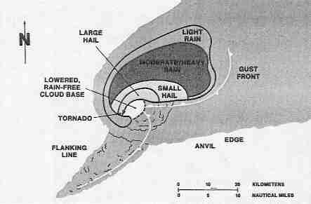
| A second
downdraft forms just southwest of the updraft. This Is the area, near the intersection of
the updraft and this "rear-flank" downdraft, where the tornado is most likely to
occur. Large hail is likely to fall just outside the updraft core, mainly northeast of the
updraft. Tornadoes may also form along the Gust Front and Flanking Line, these are usually
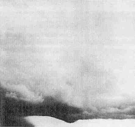
weak and short-lived. Looking back at Figure 1, we can see the primary features to look for at the cloud base. The Flanking Line Towers, Collar Cloud, and Tail Cloud are explained in the glossary. The three features of primary importance are the Rain Free Base, Wall Cloud, and Precipitation Area. In Figure 3, we are west of the storm looking east-southeast, and the storm Is moving to the left. The heavy rain area to the left tells us where a main downdraft is located. The Rain Free Base extends from under the Main Storm Tower (which is tilted slightly to the left by the upper level winds) to the Flanking Line Towers. The lowering of the cloud base near the center is a Wall Cloud. The Wall Cloud is usually in the southwest portion of the storm within several miles of the rain area. Not all Wall Clouds rotate. Nevertheless, a rotating Wall Cloud usually precedes significant tornado development from minutes to over an hour. Be alert to the fact that some tornadoes may develop from the Rain Free Base itself. |
FIGURE 2
|
FIGURE 3
|