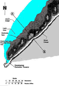
FIGURE 12
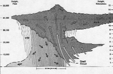
 FIGURE 13
 |
|
D. The Squall Line Thunderstorms:
Figure 12 is a view of a squall line as seen from above. Precipitation is shown in the
diagram's central area, the gust front is the white line with teeth, and the anvil edge is
in light blue. While any hail which may occur Is usually smaller than that occurring In
the tornadic thunderstorm and considerably fewer tornadoes result, strong straight-line
winds are common with squall lines. The strongest winds usually occur a few minutes after
the gust front passage, just before or just after rain and hail begin. If tornadoes occur,
they are generally weak, short-lived, and are found along the gust front. occasionally, a
tornadic thunderstorm will develop in association with a squall line. These storms
are most often on the south end or ahead of the squall line. The most distinctive cloud
associated with the squall line is the Shelf Cloud, shown in Figure 12. It is
usually located above the squall line gust front. An individual tornadic thunderstorm or
even an Isolated non-severe thunderstorm may at times develop a shelf cloud associated
with its gust front.
Before we look closer at the shelf cloud, let's take a look at a
vertical cross section of the squall line from point A to B in Figure 12. This Is shown In
Figure 13. Note that the squall line thunderstorm has a significantly different structure
that the tornadic thunderstorm. in Figure 13, the squall line is moving from left to
right. |